
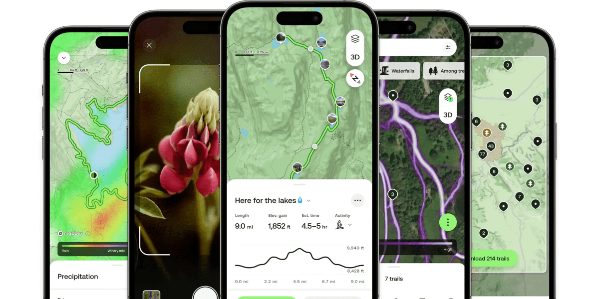
AllTrails, the hiking and biking companion that was named 2023’s iPhone App of the Year, is launching a new premium membership called “Peak” that includes an upgraded feature set. This $80-per-year subscription will introduce AI tools to build custom routes, real-time trail condition forecasts, trail traffic heatmaps, and a feature that lets you identify trees and plants using your phone’s camera.
The new option will initially roll out in the next few weeks to select members and will be available globally to all users by June. AllTrails users can sign up for early access on its website.
A longtime popular app for outdoor enthusiasts, AllTrails raised a growth round of $150 million in 2021 when the COVID pandemic saw people rekindling their relationship with nature amid lockdowns and social distancing measures.
Unfortunately for the company, Apple entered AllTrails’ market just ahead of naming it App of the Year by adding support for topographic maps with trailheads, contour lines, hill shading, elevation gains, and more in Apple Maps in the U.S. The following year, Apple encroached even further, with features like offline maps, custom routes, and tools to explore national parks and other trails outside the U.S.
AllTrails’ latest update, then, can be seen as the company fighting back with a selection of features targeted at its most engaged and most active members.

The new AI-powered feature in the Peak membership, for instance, lets users build their ideal trail either by starting from scratch or customizing existing trails. Smart-routing functionality uses AI to change a trail by making it shorter, less steep, or even “more scenic,” among other things.
The new trail conditions forecast will provide information about the temperature, precipitation, snow depth, and more, essentially putting a weather app inside AllTrails. There are also alerts for things like air quality and mosquito activity. A later update will add terrain and ground conditions, like pavement, gravel, or mud.
Techcrunch event
Berkeley, CA
|
June 5
BOOK NOW

The added heatmap option can help hikers and bikers who hate getting stuck on crowded trails, as well as those who prefer a crowd for safety purposes, like when hiking alone. To work, the app’s access to millions of users’ activity provides it with traffic data to make estimates, similar to how Google Maps uses data to predict when a store, restaurant, bar, or other venue is the most “busy.”

This summer, Peak members will also gain access to an Outdoor Lens feature, which lets them instantly identify a tree, plant, or flower and log it in the app. Over time, more identification features will be added to the Lens, the company notes.

In addition to Peak’s launch, AllTrails is rolling out updates to its Base and Plus memberships.
Base is the company’s free offering with trail maps, community reviews, and navigation, while Plus adds offline access, wrong-turn alerts, 3D trail previews, and live trail activity sharing
Both will receive a feature called Points of Interest, which adds more than 500,000 mapped viewpoints, landmarks, and trail amenities to the app. Plus subscribers, meanwhile, will also gain a feature called Offline Area, which lets them download a customized area for offline exploration that includes high-resolution maps and other details.